World Geographic Reference System
- World Geographic Reference System
A uniform position-fixing and designation system for controlling aircraft and targeting. It is better known as
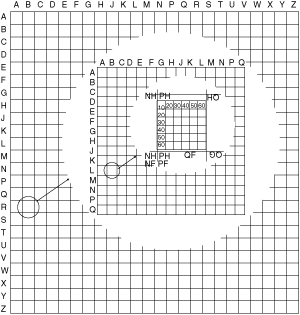
GEOREF. The system may be applied to any map or chart graduated in latitude and longitude regardless of projection. It is a method of expressing latitude and longitude in a form suitable for rapid reporting and plotting. The system is based on the division of the entire earth’s surface into a number of quadrangles and subquadrangles. The first division is into 24 longitudinal zones, each 15° wide. They are lettered
A to
Z inclusive, omitting
I and
O, and commence eastward from the 180° meridian. Similarly, the earth is divided into 12 latitudinal bands, each 15° wide. They are lettered
A to
M, omitting
I. The letters commence northward from the south pole. Each 15° quadrangle is further subdivided into 15 one-degree longitudinal zones and latitudinal bands. They are lettered
A to
Q inclusive, omitting
I and
O, and commence eastward and northward, respectively, from the southwest corner of the 15° quadrangle. Each of the subquadrangles is identified by means of four letters. The first two letters identify the 15° quadrangle, the third letter the one-degree zone of longitude, and the fourth letter the one-degree band of latitude. The one-degree quadrangles are further divided into 60 longitudinal zones and 60 bands of latitude—each one-minute of arc. Anyplace in this one-minute quadrangle is identified by quoting four letters and four numerals. The four letters denote the one-degree quadrangle; the first two numerals, the minutes of easting; and the remaining two numerals, the northing of the position within the one-degree quadrangle. In practice, where the risk of ambiguity with a neighboring 15° quadrangle I is unlikely, the first two letters of the reference may be dropped.
Aviation dictionary.
2014.
Look at other dictionaries:
world geographic reference system — See georef … Military dictionary
Geographic information system — GIS redirects here. For other uses, see GIS (disambiguation). A geographic information system, geographical information science, or geospatial information studies is a system designed to capture, store, manipulate, analyze, manage, and present… … Wikipedia
Geographic coordinate system — Map of Earth showing lines of latitude (horizontally) and longitude (vertically), Eckert VI projection; large version (pdf, 3.12MB) … Wikipedia
Military grid reference system — Geodesy Fundamentals Geodesy · … Wikipedia
British national grid reference system — The British national grid reference system is a system of geographic grid references commonly used in Great Britain, different from using latitude and longitude.The Ordnance Survey (OS) devised the national grid reference system, and it is… … Wikipedia
World Geodetic System — The World Geodetic System defines a reference frame for the earth, for use in geodesy and navigation. The latest revision is WGS 84 dating from 1984 (last revised in 2004), which will be valid up to about 2010.Earlier schemes included WGS 72, WGS … Wikipedia
system — systemless, adj. /sis teuhm/, n. 1. an assemblage or combination of things or parts forming a complex or unitary whole: a mountain system; a railroad system. 2. any assemblage or set of correlated members: a system of currency; a system of… … Universalium
Geographic feature — Geographic features, or geographical formations, are components of a planet that can be referred to as locations, sites, areas, or regions (and therefore may show up on maps). There are natural geographic features, abstract geographic features,… … Wikipedia
system — 1. [TA] A consistent and complex whole made up of correlated and semiindependent parts. A complex of functionally related anatomic structures. 2. The entire organism seen as a complex organization of parts. 3. Any complex of structures… … Medical dictionary
World Trade Center controlled demolition conspiracy theories — Aerial view of the debris field of the North Tower, 6 WTC, and 7 WTC (upper right) The World Trade Center controlled demolition conspiracy theory is a conspiracy theory which contends that the collapse of the World Trade Center was not caused by… … Wikipedia